I had a rare Saturday without any prior engagements or commitments so, naturally, I set about planning a day in the hills. Prior to the hike around Great Whernside and co. last weekend, I had planned to go back to the Yorkshire Dales, just a few miles up the road from Kettlewell, to run High Green Field Knott, Horse Head Moor and Birks Fell, ticking off another 3 Simms while getting some elevation in the running legs at the same time.
However, after experiencing how boggy it was just 6 miles south east of these mountains last week, I decided that running on that type of ground wouldn’t be easy going, and I’d probably end up walking half of it anyway, so I quickly ditched that idea. I did consider hiking it, but Rebecca and I had a weekend together without any children, so I wanted to be back for a reasonable time in the evening to enjoy that rare freedom.
Next on the thought list was Ingleborough and Simon Fell. OK, still the Dales, but the ground around that area is slightly more solid, and therefore would be less affected by the recent wet weather. However, a quick route calculation showed that I could be in the Lakes if I was willing to travel for 15 minutes longer, and so opted for the Fairfield horseshoe, with a slight deviation to also pick up Red Screes and Little Hart Crag. Then I checked the weather, and changed my mind once again.
Anything north (from the Midlands) seemed to show rain. I don’t mind rain. You can’t choose the weather on race day, so you should train in all conditions so that you are used to it. But, given the amount of rain forecast, I decided to head elsewhere. I checked the weather in the Cotswolds, which showed warm, sunny skies. As I have recently confirmed my entry into the Broadway marathon, I thought what better opportunity to recce some of the course. So off I set, with Archie in tow, for the 1 hour journey south, as opposed to the 3+ hour journey north that I was originally planning.
Parking what3words: beaten.actual.inserted
The route
The route follows a figure of 8, allowing for the course to be recce’d in two sections. Here, I decided to park in Broadway, close to the start and finish lines, and recce the first 8 miles of the course, and the last 5. I’ll return at some point to park in or around Stanway, and take in the middle 13 miles.
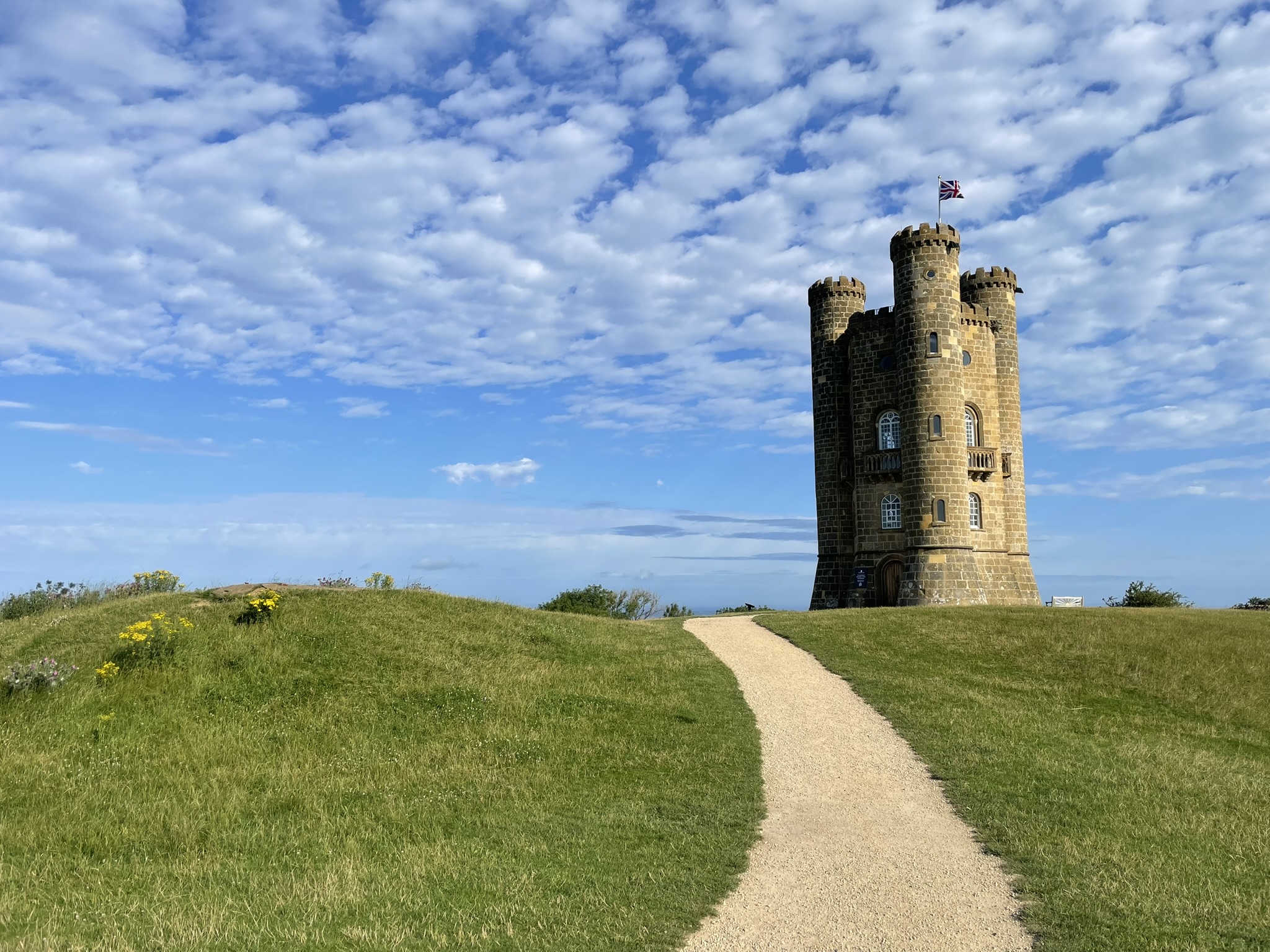
The climb up to Broadway Tower
It’s not long after the start that you turn off-road and immediately start climbing up to Broadway Tower. If you’re not familiar with the area, the tower sits at 313 m, with the village of Broadway at 88 m. This results in a climb of >220 m in less than the first two miles. Part of the thinking behind the recce was to understand just how tough this climb is. I’ve hiked down it before, but I’ve never tried going up it at pace. Given that it’s at the start of the race and, hopefully, while my legs are still fresh, I was wondering if I could run up it. Get to the tower, which is the highest point in the race, and then settle into a nice downhill to recover, and press on with the rest of my race.
That thought process didn’t last very long at all, and I can confirm now that it is very unlikely that I will be running up that section. It seems an odd strategy to expect to be walking just half a mile into a 26 mile race, but this is my first (ever) marathon, and I don’t want to cook myself in the first couple of miles. I’d rather save the legs for later on into the race, particularly as I haven’t ran this sort of distance before and don’t, entirely, know what to expect. If this puts me towards the back of the pack in the early stages, then so be it. There are some lovely views on the way up though, and once you reach the tower. It’s just a pity that these will be behind me as I progress, rather than into the direction in which I’m running.


Onwards and downwards
Once at the tower, with an average pace of 12:30, it’s time to make some progress, and that’s easy to do with almost 2.5 miles of descending, starting with a section on road. Another reason for recce’ing the course was to try and establish what shoes would be best for race day. The early climb, along with several sections later on, are on grass which, in November, can quite easily be muddy and slippery. But then there are a few long sections of road running. So I don’t want to wear full trail shoes, with big lugs, but I also don’t want to wear road shoes, which would have been OK on a dry day like today.
Here, I wore my Inov-8 Trailroc’s. A discontinued shoe which was originally designed for running over rocky trails. Since my Roclite’s have developed a rather large hole in the upper (there’s a separate discussion here on how excellent Inov-8’s are underfoot, but seemingly how poor their uppers are), the Trailroc’s are the only mid-trail shoe that I have. As it turned out, they worked well, but I’m still concerned with how soft the ground might be come winter. The Trailroc’s have a very modest lug depth of 4 mm.
After around a mile of road, you turn off through a small opening in the hedge to join a trail heading downhill towards the lower end of Snowshill. This path was so overgrown I had to resort to a walk. I’m hoping this will be chopped back come race day, as it was almost impossible to make good progress, particularly over the first part of the section. The amount of thorns and stinging nettles were ridiculous. My legs were tingling red by the end. I felt sorry for Archie, who had to go through with it all at face height.

The going does eventually improve, before rejoining the road for a near 3 mile climb (not all on road) past Snowshill Manor and Shenberrow Hill, the second tough part of the course. I did manage the entire of this section at a light jog, rather than resorting to a walk. It remains to be seen whether I opt for the same on race day. It’s a bit different getting to the top with 6 miles to go, and it being the last climb, than when there’s 20 miles left, and another tower-level climb still to come.
Don’t get lost
There are a few areas, particularly from this point on but also around the entrance onto the previous trail, where there are more than one trail choice, and it therefore becomes quite easy to end up off-course. Cotswold Trail Events, who run the race, do stipulate that the course is marked, but you can’t always rely on that, so it was good to almost get ‘lost’ here and then find my way back onto the course, so I know where I should be come race day. Rather go through that “where do I need to be; is it this way or that” on a recce than in the race. Which is why I’m determined to go back to the Cotswold’s and recce that middle section. It’s not like it’s far away from where I live.
Bring it home
From a recce sense, there’s not much more to report. The course is a real mix of roads, wooded trails and fields, some sections easier to negotiate than others. My initial goal time time was 4 hours, based on nothing more than a finger in the air. Not only have I never done a marathon, this will also be my first ever trail race, so I think I need to be realistic in what I’m aiming to achieve. Maybe use it as a learning experience to take into future races rather than have a goal time and pace that I’m striving to stick to.

Four-hour pace would be 09:05 / mile. With training, I’d probably be looking at a pace of 07:30 / mile for a road marathon. So 09:05 doesn’t seem too far off a fair estimate for a trail marathon. Here, I averaged a pace of 10:13 / mile, but I did spend a some time walking due to the vegetation growth. That also doesn’t include the stops I made for Archie, allowing him to top up on water as it was a warm day, and allowing me some recovery time in the process. In the race, I won’t be doing that, but there are still gates that require opening and closing, stiles to negotiate etc. so it’s difficult to come up with a realistic goal. I’ve started training more to effort than pace ( a post coming up on that soon) so I think that’s how I will gauge it on race day. There’s also 16 weeks of training between now and then, so hopefully where I am today is not an indication of where I will be in mid-November.